Abergavenny Active Travel scheme, Bridge connection to Llanfoist
Proposals overview
Have your Say
Thank you for visiting this page. Monmouthshire County Council (MCC) and its local partners are seeking your views on the proposed Active Travel links between the proposed Llanfoist Foot and Cycle Bridge across the River Usk and Llanfoist to the south. The scheme will tie into work being undertaken in relation to the provision of the proposed Llanfoist Foot and Cycle Bridge and the proposed improvements within Castle Meadows. More specifically, the scheme proposes to:
- Provide a safe and appropriate Active Travel route for pedestrians, cyclists and those with impaired mobility, between the proposed Llanfoist Foot and Cycle Bridge across the River Usk and Llanfoist to the south (and vice-versa).
- Make sustainable transport choices more attractive, thus reducing emphasis on private car use.
- Improve highway crossing facilities for pedestrians, cyclists, and those with mobility impairment, within Llanfoist.
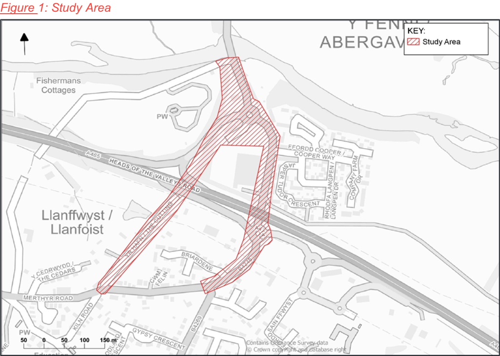
The extent of the scheme can be seen in Figure 1.
Why are improvements needed?
Abergavenny is one of the key strategic sites not only in Monmouthshire but for the County’s bordering towns. It acts as the main retail, educational, and cultural centre for an extensive rural area, extending into the old Greater Gwent authority areas and Herefordshire.
Abergavenny, situated in the north of Monmouthshire, acts as a retail, educational and cultural hub for an extensive rural area, extending into the old Greater Gwent authority areas and Herefordshire.
The A4143 Merthyr Road connects the two communities of Abergavenny and Llanfoist via the existing Llanfoist Bridge, which crosses over the River Usk. Castle Meadows and Ysbytty Fields are important leisure areas for the community and are crossed by Public Rights of Way (PRoW) and National Cycle Network (NCN) Routes 42 and 46.
To date, study findings suggest that many people who would otherwise walk or cycle between Llanfoist and Abergavenny are deterred solely by the poor pedestrian and cycling facilities. Those with impaired mobility are particularly disadvantaged by the current facilities.
Key issues relevant to the scheme’s area have been identified during the early stages of the study and are summarised below:
- The existing road network in the area is extremely busy, making the environment unappealing for pedestrians, cyclists, and those with mobility impairments. Analysis of 2011 Census data identified that 15% of drivers in the area travel less than 2km and 8% between 2km and 5km. Some of these trips could be accommodated by Active Travel modes if adequate Non Motorised User infrastructure would be provided.
- There is currently no off-road cycle facilities, as such cyclists have to use the existing carriageway/s to travel.
- There is a lack of adequate crossing facilities at the “Waitrose” roundabout.
- At sections of the scheme, footways are narrow and sub-standard, forcing pedestrians into close proximity to the carriageway and traffic.
- There are significant perceived road safety issues, particularly along Merthyr Road between the Bridge Inn pub and ‘Waitrose’ roundabout.
- The Cutting is recognised as a quiet-way, and as such, has the potential to accommodate more cyclists’ movement.
- The current route behind Waitrose Petrol Station is narrow and overgrown.
Objectives of the Scheme
The scheme’s objectives have been derived by identifying key issues (as summarised above) and according to the objectives set by the MCC and Welsh Government (WG) transport policies. The objectives are as follows:
- Improve access to local services, employment, and cultural facilities by Active Travel modes by improving connectivity between Abergavenny and Llanfoist.
- Promote and facilitate healthier lifestyles by increasing the number of pedestrians and cyclists using Merthyr Road and The Cutting for commuting purposes.
- Make a positive contribution to air quality by promoting active travel in MCC and supporting the reduction of Carbon Dioxide around the Abergavenny / Llanfoist area.
- Introduce safe and accessible active travel links and remove conflicts between users around the ‘Waitrose’ Roundabout.
- Provide a coherent, direct, and future-proof cycle route which connects with the existing and planned active travel infrastructure.
The scheme proposals are anticipated to encourage the public to adopt walking and cycling as preferred modes of travel. Also, it is considered the scheme may help benefit the local environment by reducing carbon emissions.
Scheme Proposals
Overview
The scheme proposes:
- The widening of the existing footway along the eastern side of Merthyr Road between the Bridge Inn pub and ‘Waitrose’ Roundabout, to accommodate a 3.5m wide shared (pedestrian and cycle) route. To accommodate this proposal, on-street parking at this location will be removed.
- The provision of new crossing facilities across three arms of Merthyr Road.
- The widening of the existing footway along the eastern side of Merthyr Road between Waitrose Roundabout and the Heads of Valleys Slip Road / Merthyr Road Roundabout to the south to accommodate a 3.5m wide shared (pedestrian and cycle) route.
- The widening of the existing footway along the eastern side of Merthyr Road between the Heads of Valleys Slip Road / Merthyr Road Roundabout and Gypsy Lane, to accommodate a 3.5m wide shared (pedestrian and cycle) route.
- The provision of improved more direct crossing points across Coopers Way and the eastern and western arms of the Heads of Valleys Slip Road / Merthyr Road Roundabout.
- The widening of the existing footway along the back edge of the car park located to the immediate north of ‘Waitrose’ Roundabout, to accommodate a 3.5m wide shared (pedestrian and cycle) route. This will involve a slight relocation of the existing car parking southwards (with the loss of one space) and the provision of two spaces to the western side of Merthyr Road adjacent to Kwik Fit (leading to an overall net gain of one space).
- The widening of the existing footway along the back of Waitrose Petrol Station between ‘Waitrose Roundabout’ and The Cutting Heads of the Valleys Road underpass, to accommodate a 3.5m wide shared (pedestrian and cycle) route.
- The promotion (through additional signage and road markings) of The Cutting (without impacting the existing access and parking arrangements) between The Cutting Heads of the Valleys Road underpass and Merthyr Road to the south as a quiet-way for pedestrians, cyclists and those with mobility impairment.
- The improvement of the existing The Cutting and Merthyr Road priority junction arrangement.
Merthyr Road
As detailed above, it is proposed to upgrade the existing footway along the eastern side of Merthyr Road between The Bridge Inn pub and Gypsy Lane to accommodate a 3.5m shared route, which would be suitable for pedestrians, cyclists, and those with mobility impairment to use.
This will be achieved by widening the existing footways into the existing carriageway. To accommodate this, there will be a need to remove the existing on-street car parking along the eastern side of Merthyr Road between the Bridge Inn pub and the ‘Waitrose’ Roundabout. There will also be a need to remove the existing bus layby, located between ‘Waitrose’ roundabout and Coopers Way on the eastern side of Merthyr Road, and re-provide the bus stop in the same location but instead on carriageway.
It is proposed to upgrade the existing uncontrolled crossing points on the southern, northern, and western arms of ‘Waitrose’ Roundabout to zebra crossings.
To accommodate the wider route to the rear of the car park located to the immediate north of the ‘Waitrose’ Roundabout, it is proposed that the existing car parking be relocated southwards. This will result in the loss of one space; however this will be re-provided as part of the two spaces being proposed on the western side of Merthyr Road adjacent to Kwik Fit (leading to an overall net gain of one space).
At Coopers Way it is proposed to provide a Toucan crossing, which will enable a more direct connection for future users over the current arrangement.
At the Heads of Valleys Slip Road / Merthyr Road Roundabout, it is proposed to replace the existing signal controlled crossing located on the eastern of the roundabout with a zebra crossing. This will be located closer to the roundabout to provide a more direct connections for future users over the current arrangement.
Whilst it does not form part of the proposed shared route along the eastern side of Merthyr Road, to aid future pedestrian connectivity, it is also proposed to upgrade the existing uncontrolled crossing points on the western arm of the Heads of Valleys Slip Road / Merthyr Road Roundabout to a zebra crossing.
The above proposals are illustrated in Figures 2 and 3 below.
Figure 2: Proposals along Merthyr Road
Figure 3: Proposals along Merthyr Road
The Cutting
As detailed above, it is proposed to widen the existing footway along the back of Waitrose Petrol Station between ‘Waitrose Roundabout’ and The Cutting Heads of the Valleys Road underpass, to accommodate a 3.5m wide shared (pedestrian and cycle) route. This is not anticipated to impact on the existing vegetation along the route.
It is also proposed to promote (through additional signage and road markings) The Cutting (without impacting the existing access and parking arrangements) between The Cutting Heads of the Valleys Road underpass and Merthyr Road to the south as a quite-way for pedestrians, cyclists and those with mobility impairment.
To aid with access at the southern end of The Cutting, it’s proposed to improve, by tightening existing radii’s, the existing priority junction arrangement with Merthyr Road. This will involve formalising the existing parking located on the western side of the junction, in front of properties 1-4 The Cutting.
The above proposals are illustrated onin Figures 4 and 5 below.
Figure 4: Proposals along The Cutting
Figure 5: Proposals along The Cutting
Your Opinion
Your opinion on the proposals matters to us. As such, we ask that you please complete the survey at the below link and include your postcode.
The survey asks some general questions about the way you normally travel in the study area before asking about your experiences in travelling between the existing Llanfoist Bridge and Llanfoist. The survey then asks you to rate the proposals as set out above.
Please encourage members of your household and others to undertake the survey since your responses may not necessarily reflect the views of others.
Take part in the Llanfoist active travel survey.
This post is also available in: Welsh