Caldicot Active Travel scheme, Woodstock Way
As part of developing the wider Active Travel network for Caldicot and the Severnside area, Monmouthshire County Council (MCC) is proposing alteration of the design and traffic management for Woodstock Way in central Caldicot to improve active travel links to and from Caldicot School, Caldicot Leisure Centre and other local destinations. Subject to funding, later phases will improve further active travel links across the Severnside area of south Monmouthshire.
Phase 1 of this programme is to provide safer crossing points and efficiently manage traffic on Woodstock Way. Funding to build Phase 1 was secured for this year, as research and design had reached the necessary stage for consultation and implementation. We are concurrently working on connecting schemes across Severnside, and plan to follow this scheme with active travel improvements to Mill Lane, which leads from Woodstock Way to Caldicot School entrance, the leisure centre and Park & Stride car park, Durand Primary School and homes in south-east Caldicot.
These proposals are developed in response to local issues and needs that have been identified by the County Council and other local organisations. There is a need for safer routes and crossing points for walking and cycling, with better management of traffic speeds, congestion and hazardous parking, particularly during drop off and pick up times, with the aim to improve the safety and quality of the environment for local people and for those travelling around Woodstock Way.
We aim to make it easier to make short, local trips by sustainable and active modes. Walking, wheeling and cycling to destinations (also known as Active Travel) can have a positive impact on physical and mental health, ability to learn and concentrate, and open up affordable access to local shops and services, employment, education and cultural destinations, and public transport connections.
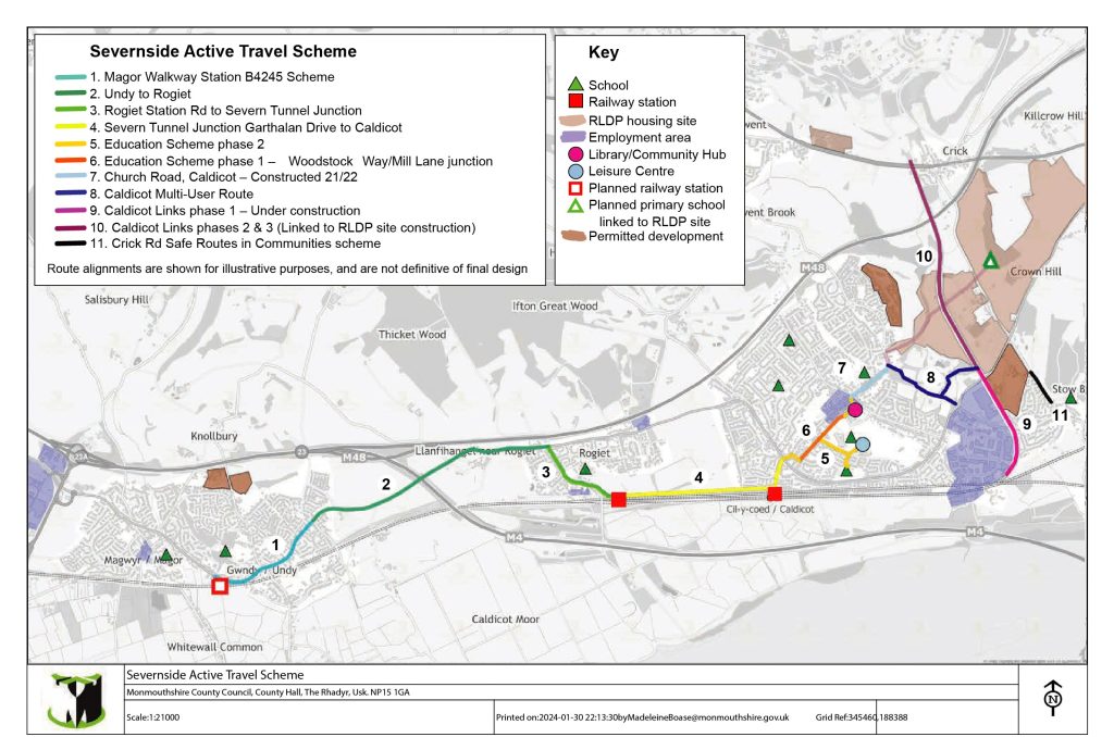
Image: Severnside indicative active travel overview
Phase 1 proposal overview
Caldicot Active Travel Education Scheme phase 1 will upgrade active travel paths and crossings along Woodstock Way to address issues of safety, path quality and congestion. The route improvements in this phase will connect to the wider Severnside Active Travel scheme in later phases. This section has been progressed with urgency because it is a major route to important local services, including Caldicot School, Gray Hill Surgery, Library and Leisure Centre.

Image: Woodstock Way scheme overview
- Widening and resurfacing of the north side Woodstock Way footway from the southwest end of Woodstock Way (where it meets the B4245) to just beyond the Mill Lane junction, to make a 3-metre-wide shared use active travel path. Signage and tactiles will be installed to indicate shared-use designation.
- Widening and resurfacing of the south side Woodstock Way footway from the Mill Lane junction to the crossing outside Aldi to make a 3-metre-wide shared use active travel path.
- Installation of traffic lights with smart Toucan crossing facilities at the Mill Lane junction on Woodstock Way (by Gray Hill Surgery/ Caldicot School) to improve safety of traffic flows (vehicle and active travel). This includes three lateral crossings and a diagonal crossing from Norman Court to the Gray Hill/Caldicot School corner, to efficiently route the main flow of active travel traffic at peak times.
- Narrowing and resurfacing of the south side footway of Woodstock Way from Durand Road to Mill Lane to – at minimum – a width of 1.5 metres. This will allow for widening of the opposite pavement.
- Conversion of existing Puffin (signalised, pedestrian only) crossing outside Aldi to a Toucan crossing (signalised, walking and cycling).
- Repositioning of Gray Hill Surgery bus stops (north and south side) eastwards along Woodstock Way, towards the pedestrian cut-through to the town centre, and away from the Mill Lane junction.
- Upgrade of bus shelters to include information boards and green (sedum) roof
- Removal of Aldi bus stop (south side) as the Gray Hill bus stop would be moved closer.
- Signage to indicate traffic order to restrict Heavy Goods Vehicles from turning off Woodstock Way southwards onto Mill Lane (buses excepted).
- Integration of tactile paving, dropped kerbs and signage throughout to improve route visibility, and access for disabled people.
- Update of road markings.

Image: Woodstock Way and the local area
Consultation
A consultation was held 27th August – 25th September 2024 and we will share findings on this page.
Scheme drawings
To increase/decrease the size of the diagram, click the plus/’+’ and minus/’-‘ buttons in the bar at the top of the diagram window. To pan across and up/down, drag the sliders across the bottom and right-hand side of the diagram window. To open the diagram as a full page, click on the link below the diagram window. This will open the diagram in a new window, with the same increase/pan controls as described above. You can also download the image by clicking ‘Download’
Scheme drawing – Existing layout:
Scheme Drawing – Proposed layout:
Scheme Drawing – Detail of Woodstock Way/Mill Lane junction proposed layout:
Woodstock Way Scheme Question and Answer
What is active travel?
Active Travel is a term used to describe walking, wheeling or cycling to a destination (also called “purposeful journeys”). It does not cover walking and cycling done purely for leisure although it could significantly enhance leisure activities by helping to link up networks. Active travel can be used to get to school, work, services and shops, or as one of several modes on a longer journey – for example, walking to the station to catch a bus or train. MCC’s active travel strategy focuses on journeys of three miles or less, which means improving walking and cycling infrastructure within communities, to make active travel the first natural choice for local journeys.
This scheme is funded through the Welsh Government Active Travel Fund, with funding awarded through a competitive bidding process. The funding obtained is scheme specific and cannot be spent on anything else.
Why is this scheme needed?
This scheme is needed to improve the safety of Woodstock Way and sustainably meet the travel needs of people in the area. It is designed to address multiple issues, in a way that is cost-efficient, more holistic and less disruptive than tackling them individually. Monmouthshire County Council (MCC)’s business case for this scheme has secured funding and seeks to maximise beneficial outcomes, through its strategic focus on active travel links to education and services, which in this area include Caldicot School, Leisure Centre, GP surgery, town centre and the Library/Hub.
Woodstock Way is a busy road where incidents of road danger involving Caldicot School students have been reported, and high traffic levels were observed during peaks causing congestion and safety concerns. The design of the area has an effect of how people travel, and the safety and attractiveness of that experience.
Our vision for the area is one where people have fair and convenient access to travel and transport options that are best suited to each trip, thereby improving connectivity and reducing the inequalities created by over-reliance on driving. Just over one fifth of adults in Monmouthshire have obesity, and more than one third do not do enough physical activity (source: British Heart Foundation 2023). It is generally recognised that walking and cycling paths need to be improved so that active travel (walking, wheeling and cycling for purposeful journeys) is an attractive and viable option, because that drives ‘modal choice’ (how people choose to travel) has a knock-on economic effect through consequences to our health and wellbeing, the environment and the quality of the local area.
To further understand the local travel and transport issues around Woodstock Way, we engaged with the primary local sources of traffic (of any mode, i.e. drivers and users of public transport and active travel). In 2020-2022 MCC commissioned Amey Consulting to study the area around Caldicot School and Leisure Centre. Conversations have been held with the Gray Hill surgery. Leisure centre users were consulted in 2020. Caldicot School students were consulted in 2021 on issues faced in commuting to school. Hazards and perceived danger were mentioned regularly, related to narrow pavements, heavy goods vehicle traffic, anti-socially parking and congestion during school pick-up and drop-off times. Students reported cramped and uneven pedestrian infrastructure and inaccessible pavements, with a lack of drop kerbs for wheelchair users even forcing them to use the road. Routes for cycling were also reported as inadequate and inconsistent. High traffic volumes make it difficult to cycle on the roads without segregated facilities. Crossing roads was another difficulty faced by Caldicot pupils, whether walking, wheeling or cycling, due to the volume and speed of traffic. The responses highlighted the need for a crossing on Woodstock Way at the corner of Mill Lane, as the nearest formal crossing is too far from the schools and does not serve active travel traffic from south and west Caldicot via Woodstock Way and Norman Court. Other factors that influenced the use active travel to get to school included time pressures, distance, weather conditions and the social aspect of commuting with peers.
From a study of the wider area, there are these specific issues on Woodstock Way:
- Major safety concerns associated with students crossing at the junction in all directions. Poor visibility for drivers at Mill Lane junction due to over-parking on Woodstock Way
- Insufficient footway width at the bus stop opposite Gray Hill Surgery, resulting in pupils blocking footway and spilling onto the carriageway
- Footway width restriction and poor surface quality
- Lack of necessary signage on Woodstock Way
Unpredictable crossing/parking was also observed, The consultants then prepared the proposed scheme as a Full Business Case, based on a range of evidence including interviews, observation, traffic surveys (including walking and cycling counts) and studies of the drainage, topography, land ownership, etc., to meet the objectives of the Council and the Active Travel Fund.

Image: Amey 2022 Site visit photos
This scheme has been designed around this consultation, which showed that safety and active travel infrastructure improvements are needed. Beyond safety and traffic management measures, high quality active travel routes are needed to support everyone, including students, to live active, healthy and connected lives.
Why has Woodstock Way been prioritised over other schemes?
A limited number of schemes can be progressed each year. Funding for this scheme was secured for this year, as research and design had reached the necessary stage for consultation and implementation. Woodstock Way was identified as a walking/wheeling and a cycling route in the ATNM (Welsh Government’s Active Travel Network Map) consultation in 2020-2021. It is a Very High Impact route on the Transport for Wales route impact tool, based on its central location and proximity to schools and other services, and this underlines the need to address the safety issues on the route as a matter of urgency.
We are building a network of routes throughout the County. Woodstock Way and its junction with Mill Lane has been prioritised as an active travel scheme because it is a main route to Caldicot School, with risks associated with school start and end times, but it’s also a town centre route to other destinations that attract traffic, be it by foot, wheeling, cycling, mobility scooter, bus or private vehicle. Destinations in the vicinity of this central road include Gray Hill Surgery, the town centre, bus stops, the leisure centre, Library/Hub and TogetherWorks, supermarkets, car parks and other local services, and there’s also through-traffic and recreational travel to consider.
The Woodstock Way scheme has ring-fenced and time-limited funding from the Welsh Government’s Active Travel Fund for financial year 2024-25. MCC successfully secured Welsh Government funding for this scheme by prioritising high-potential, central routes near schools, transport hubs and other services. This route has been prioritised because of the safety issues, and because it meets the criteria to maximise the impact of investment in active travel.
When will the route be constructed?
MCC is aiming to progress this project following public and stakeholder consultation, subsequent finessing of designs and a successful tender process.
How will the scheme be funded?
The scheme is to be funded through the Welsh Government’s Active Travel Fund. This funding stream is ringfenced to improve active travel infrastructure within larger settlements. Active travel infrastructure improvements support other policy areas, such as health and wellbeing, air quality, road safety, the Socio-economic Duty and placemaking/regeneration. The funding is administered by Transport for Wales on a competitive basis, where Monmouthshire County Council has bid for the funding to improve the Caldicot and wider Severnside area, creating safe and equitable access to sustainable transport for everyday journeys in Severnside.
The grant objectives of the Active Travel Fund, by which funding bids are assessed:
- Encourage modal shift from car to active travel in isolation or in combination with public transport
- Improve active travel access to employment, education, key services and other key traffic generating destinations
- Increase levels of active travel
- Connect communities
Have grants been secured for the proposals?
Funding has been secured in principle to complete the proposed works this financial year following a period of consultation and any following design amendments. This funding is time-limited and ring-fenced.
What about the rest of the area – does this mean other schemes in Severnside are de-prioritised?
No, this is just the scheme at the highest level of development fidelity following the Welsh Governments Transport Appraisal guidance (WelTAG).
MCC is developing an active travel network for the growing population across the Severnside area, with a range of schemes and minor works being brought forward as funding and processes allow. This is called the Severnside Active Travel Scheme. The survey of Caldicot School students in 2022 also highlighted the need for safe and practical active travel routes linking to Caldicot for the services that are shared across Severnside such as the secondary school, library and leisure centre. MCC is working through Welsh Government’s Active Travel Network Map and Active Travel Fund to futureproof travel and transport options for the residents of Caldicot, Crick, Caerwent, Portskewett, Undy, Rogiet and Magor, and support sustainable travel in and out of the area.
The Severnside active travel map (below) is indicative of the general areas of focus as we develop routes to central destinations in Severnside. The Woodstock Way scheme is shown on the map as 6. Education Scheme Phase 1 (red line). Routes are shown on the map for illustrative purposes and are not definitive of final network design. Other parts of overall Severnside active travel network are at earlier stages of development, and we will update the map as and when route alignments are established. Connections through Caldicot town centre will be the subject of a separate study.
Why Woodstock Way and not Newport Rd?
Newport Road was subject to a trial closure in the Autumn of 2022, scheme consultation following this trial indicated the strong desire for the road to remain open to 2-way through traffic. The space available within the carriageway does not allow for significant improvements to walking and cycling infrastructure along its length. A funding bid was submitted to redesign the road in light of the consultation results and with improvements for pedestrians where possible. Unfortunately this was not supported by the funding body.
During the progress on Newport Road, a separate scheme was underway looking at improvements around Woodstock Way and Mill Lane, including the improvement to pedestrian crossing facilities in the vicinity of the school. This scheme gained traction with the funders and is now what is presented here.
Will traffic be diverted onto Newport Rd?
Woodstock Way will remain open to 2-way traffic and the road widths will remain within standards. No impact is foreseen on motor vehicle traffic with the current 20mph speed limit.
How will this affect parking?
There will be localised road narrowing around the Woodstock Way/ Mill Lane junction at the new signalised crossing. Vehicle tracking analysis has established the feasibility of the planned road widths. To maximise parking within the redesign, and as a safety measure, a new Traffic Regulation Order (TRO) will restrict very large lorries from entering Mill Lane.
The standard restriction on informal parking in the vicinity of junctions, as per the Highway Code, will be maintained to allow safe sightlines around the crossings. Access to residential driveways on Woodstock Way will be maintained.
Woodstock Way is well served for visitor parking, with Woodstock Way MCC free car park and the Asda and Aldi car parks. In addition to supporting better use of capacity in the MCC car park by improving the entrance sightlines on Woodstock Way, the scheme is aimed at encouraging modal shift (converting some short car trips to walking or cycling) thereby reducing pressure on parking for those who need to drive.
What is a ‘shared use active travel path’?
A shared use path is a path for use by any mode of active travel, be it walking, wheeling or cycling, without any physical separating features or markings. The proposed shared use path is designed as three metres wide, in accordance with Active Travel Act guidance. Illegal use of active travel paths by motorbike and e-scooter riders is a police matter and should be duly reported by calling 111.
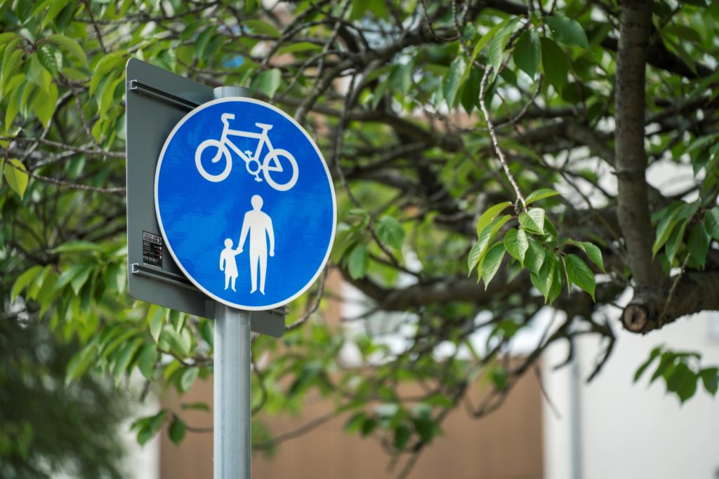
Image: Shared Use path roundel sign
This scheme includes widening sections of footways of Woodstock Way to accommodate a shared use active travel path that will be open for use for walking, wheeling (wheelchair, mobility scooter, kick scooter, etc.) and cycling. Specifically, the Woodstock Way north-side footway from the B4245 end of Woodstock Way to just beyond the Mill Lane junction, and south-side Woodstock Way footway from the Mill Lane junction to the crossing outside Aldi. Signage and tactiles will be installed to indicate shared-use designation. The routeing is designed around surveys of local active travel flows and traffic modelling.
Shared use paths allow for people walking, wheeling and cycling to use the same path, with enough width for it to be comfortable to walk with a buggy, use a mobility scooter, or accompany a child on a bike. An observation from other active travel schemes is that shared paths are conducive to considerate and slower-paced use: – where cyclists want to travel fast, they opt to use the road instead.
How does this scheme connect to the railway station?
The scheme is one part of a series of projects to connect through all of the Severnside communities. Projects are proposed to link into the railway stations, and we will progress these as resources and prioritisation allow.
How does this scheme connect to Mill Lane?
The Woodstock Way scheme is part of the Severnside Spinal Route. Building on the Woodstock Way scheme, designs are in development to (subject to funding and approval) continue the shared use active travel paths from Woodstock Way down Mill Lane to the entrance to the Leisure Centre car park, increasing capacity for active travel and creating a more direct Park & Stride route to Caldicot Comprehensive School from the Leisure Centre car park. This will address the safety and accessibility of routes to Caldicot School and Durand School, whilst improving the quality of place and green space along Mill Lane.
Won’t new traffic lights and crossings cause traffic jams?
The impacts of signalising the junction were tested using LinSig traffic modelling of observed pedestrian, cycle and vehicular movements through the junction at peak times. The results of the model show that signalised junction is slightly over capacity in the afternoon peak (105%), but this only results in a maximum queue length of less than 3 vehicles in the peak period and should be mitigated over time by modal shift encouraged by better active travel provision. The queue modelling should be compared to the current situation, which is a lack of safe crossings, or the suggested alternative, which is a zebra crossing and several informal crossings that will cause congestion differently (see below). It is possible that there will be a short-term peak in congestion after the scheme is constructed: this is typical of remodelled junctions, as it takes a few weeks for people to get used to changes to a route that they are familiar with.
The advantage of providing signalised crossings across all arms of the junction is that it caters for all pedestrian and cycle crossing movements in the most efficient way possible. On site observations and surveys show that the crossing movements are spread out across all arms of the junction as well as diagonally across Woodstock Way. It will also prevent vehicles from stopping in the mouth of the junction to let out pupils (this currently happens causing further congestion and confusion and increasing the potential for conflicts).
Advances in signal-controlled crossings will assist in the efficient control of traffic flows: Firstly, the new traffic signals will detect the presence of approaching vehicles on both the main line and the side road, as well as pedestrians and cyclists waiting at the kerb side or crossing the junction. The vehicle detectors will prioritise green-light time to the main road demands on Woodstock Way and will only stop main road traffic when there is a demand from traffic approaching from Mill Lane, or when the push button is pressed for the pedestrian/cycle crossing.
Secondly, detectors on the crossing facilities will detect the presence of pedestrians and cyclists and extend the crossing period time to suit. This means that traffic is only held for as long as needed and accommodates those who may need longer to cross (such as elderly/mobility impaired). Lastly, sensors on the kerbside will check the presence of people waiting to cross so, if someone presses the push button but walks away, the crossing phase will be cancelled allowing main line traffic to continue.
Wouldn’t a simple crossing, without the rest of the scheme, be quicker and cheaper?
If, instead of the proposed active travel scheme, a single zebra crossing was to be installed on Woodstock Way, this would only cater for one pedestrian crossing movement but may cause traffic to be stopped more often due to lack of provision for other crossing movements and the school peak period arrival and departure profile. The main pedestrian desire-line crossings (established in the preparatory traffic surveys) focus around the Mill Lane junction: a standalone zebra crossing in this location would either have to be placed too far from the junction to solve the safety issue, or fail safety audit and not be buildable, without the proposed measures surrounding it.
The proposed scheme addresses both current issues and future/growing problems with a secured source of funding. Road traffic danger has been highlighted, but the installation of a crossing on its own would not effectively address the systemic structural and behavioural legacy that underlies the current safety issue. Particularly at school start and end times, there is a clear need for improved route accessibility, traffic flow control (vehicular and active travel), wider paths and safer crossings serving several routes. In addition, there is the potential to address comprehensive issues to make active travel attractive enough to support even more people to leave the car at home for local trips. This scheme includes safe infrastructure for wheeling and cycling, vital to making active travel accessible, safe and practical. This scheme is designed to be cost-effective and ambitious in addressing multiple issues, from urgent questions of road safety to more general problems with public health and sustainability, in a way that is less disruptive than tackling them individually.
Why does the scheme have to be built to Active Travel standards?
This scheme is funded through the Welsh Government’s Active Travel Fund. This funding is ringfenced for active travel and, as such, the scheme must meet the specifications of the Active Travel Act guidance and evidence that it is focused on achieving the Wales Transport Strategy’s outcomes including modal shift, through the Welsh Transport Appraisal guidance (WelTAG) process.
Why do we need active travel routes in Caldicot?
Walking and cycling can be a useful, low-cost, efficient way to get about the town. Where students can walk to school, they are better able to concentrate, maintain good health and build social connections. MCC is working to support them, and everyone else too, to be more active because it benefits everyone’s health and wellbeing, as well as the environment and the community. We have seen an increasing proportion of short, local trips made by car: This creates a vicious cycle of congestion and feeling of risk that puts people off active travel. Some priority routes around schools, such as the junction of Woodstock Way and Mill Lane, urgently need to be re-designed to boost the safety, attractiveness and practicality of active travel for short, local trips.
Why not develop the King George V path?
The King George V path has been put forward as an alternative route connecting Church Road to Caldicot Station. It has not been prioritised for development or funding bids over Woodstock Way because of its location, and because it is narrow and isolated in places, though it remains on the Active Travel Network Map for addressing in the future. Woodstock Way, on the other hand, is adjacent to the Comprehensive School and there have been specific incidents of clashes between road and active travel traffic that have made this road the focus of the safety and quality design improvements. Woodstock Way is a wide route, with potential capacity for high volumes of active travel traffic.
Why are the bus stops being moved, and one bus stop being removed?
The Gray Hill Surgery bus stops (north and south side) will be repositioned eastwards, towards the supermarkets, Hub & Library and pedestrian cut-through to the high street, and away from the Mill Lane junction. This is designed to improve safety and visibility at the junction and better distribute the bus stops on Woodstock Way to bring the Gray Hill stops closer to the town centre. Studies of traffic flows in the area have shown that bus stops are currently too close to the junction which both creates risk and makes an unpleasant experience for those waiting when the junction is crowded. The Aldi bus stop (south side) will be removed as the Gray Hill bus stop would be 60 metres away, and the following bus stops are accessible at Caldicot Cross. The Woodstock Court bus stops will remain in the same place. The route of the public bus will remain the same. The bus shelters will be upgraded to include information boards and green (sedum) roof for access and environmental benefits.
Why doesn’t the scheme extend around the Asda corner?
Funding was provided to address problems around the school. It was assessed that this phase of the design should end at the Aldi crossing, where the main flow of active travel traffic will be heading towards the town centre, rather than continuing along Woodstock Way. Footway provision around Asda is already rollable and of a suitable width, so would not currently attract funding.
What about disabled access?
The accessibility of the route is central to the design and its funding, and particularly important to its proximity to Caldicot School and the Nurcombe Centre for students with additional learning needs (ALN), and the GP surgery. The current problems with local pavements, including a lack of drop kerbs, particularly affects the access, safety and comfort of people with disabilities, as highlighted in our 2022 consultation.
Paths will be designed and constructed according to the Active Travel Act guidance, ensuring that accessibility is considered throughout, both in the material infrastructure, signage and surfacing, and as part of a connected network. This means that design of the crossing facilities at the Mill Lane junction creates a more convenient and direct route, so that people aren’t forced to go a long way out of their desire-line along their route in a way that is particularly arduous for people with mobility restrictions and using wheelchairs.
We want to ensure that Woodstock Way active travel routes are accessible and attractive to everyone, including those with disabilities and reduced mobility, and/or travelling with children and/or baggage. Wider paths and clearer indication of routing are designed to reduce the potential of clashes between different traffic streams and improve the comfort and sociability of active travel. Safer, formalised street crossings with sensor-led smart phasing will further improve the accessible and intuitive function of the active travel paths.
How are people supposed to get to the town centre?
Existing walking/wheeling routes between Woodstock Way and the town centre will not be affected by this scheme. Improvements to connections into the town centre will be a later phase of development of the Severnside active travel network. There is currently rollable access from Woodstock Way to the town centre via the two routes through the Wesley Buildings (Bargain Booze/Davies & Son and Aldi/Dominos) and from the Library/Hub to the Cross, which will not be negatively affected by this scheme.
Will the scheme take trade away from the centre of Caldicot?
Good quality active travel infrastructure supports local shops and high streets by making it easier to get into the town centre for Caldicot and Severnside residents. We are working to increase the attractiveness and convenience of walking, wheeling and cycling to local shops as an alternative to driving out of town or to the supermarket. Access to active travel supports the regeneration of characterful, resilient and sustainable communities, for the health and wellbeing of current residents, a growing local population and for future generations.
This scheme will improve connections to existing walking/wheeling routes between Woodstock Way and the town centre, with later phases of the scheme linking-in Mill Lane and Caldicot station, to enable more local people to shop locally, benefiting from the financial savings and social opportunities that accompany better access to active travel.
Where cyclists want to commute past the town centre, this scheme will improve their safety on Woodstock Way, whether using the road or the active travel path. Caldicot town centre is pedestrianised. Mobility scooters are accommodated, and cycle parking is provided at either end of the pedestrianised area, giving competitive advantage to active travel over car parking in the area which can be enhanced by improving routes that connect to the town centre, such as Woodstock Way.
How has the consultation been promoted?
The consultation has been promoted via local poster distribution, as well as on the Monmouthshire County Council website, local newspapers, and social media. We have delivered information on the proposed double-yellow line extension to the residents that will be directly affected by this change. This approach is to ensure that, outside of the few households directly affected by the double-yellow line extension, we give equal treatment to the views of people who live in and use the area, regarding their need for safe and comfortable use of the space.
This post is also available in: Welsh